A Linear Walk over Blencathra
A mountain ascent without a Sharp Edge
The Lake District is a wonderful destination for a weekend away. It is a regular treat for me to meet up with friends and escape into superb scenery and physical challenges that blow the day-to-day worries away from my mind with the very first sight of the mountains.Keswick is is lovely little town surrounded by peaks and situated at the side of one of the larger lakes in the Lake District, Derwentwater. I have lost count of the number of weekends I have spent here yet there are still plenty of walks to do and mountains to climb.
The main walk on my recent visit was a linear walk over Blencathra (aka Saddleback), starting in Scales to the east and heading up over Scales Fell to the top of Blencathra and then down to the west ending in Threlkeld.
 |
| Footpath up to Hallsfell Top, the summit of Blencathra |
If you would like to try this walk yourself here are the details.
Parking is always tricky, especially in summer. For this walk we took two cars, parked one car in the parking area at the top of Blease Road in Threlkeld then we all went to the start of the walk in Scales and parked the other car in a parking area to the east of the village.We found a path to Scales Fell behind the White Horse Inn and Bunkhouse, following this steeply up through one field and then followed the path to the right to swing round and up the hill.
The route is shown on the maps below, the path we took (highlighted in yellow) to the south of Scales Tarn is the easier route. The red circle / lasso shows the trickier route which goes over Sharp Edge (not for the faint-hearted). It was a blustery day so we were glad we didn't do the Sharp Edge route, although the wind didn't deter other hikers as we watched them scrambling along the edge.
 |
| Simple route over Blencathra |
 |
| Detailed map of the route |
Looking back as we walked up Scales Fell we had views over Great Mell and Little Mell fells.
 |
| Climbing up Scales Fell with Great Mell in the distance |
The wind gusted quite strongly as we ascended the fell and we were quite surprised to see other hikers attempting Sharp Edge. Even on Scales Fell one gust almost knocked one of our party over and he just managed to recover his footing.
 |
| Tiny dots of hikers on Sharp Edge |
Just below the path heading up Scales Fell we found a slightly sheltered spot and took a rest to admire the view over Scales Tarn and Sharp Edge.
 |
| Taking in the view over Scales Tarn and Sharp Edge |
Higher up, the path splits and we took the zig-zag route to continue the climb. Blencathra summit is 867m high and the views on the approach and at the top are extensive.
 |
| Looking over Doddick Fell |
We were warned by a passing hiker to be careful at the top as the wind was gusting hard, but actually it wasn't too bad once we reached the top. The weather was changing, we could see the clouds gathering over the mountains and rain was forecast (and arrived) that evening.
 |
| The view from the top of Blencathra, including Thirlmere and Derwentwater |
The footpath continues down to the west from Hallsfell Top and views over the western fells open up. The going got easier and it was a delight to see the mountains and views over Keswick and Bassenthwaite Lake as we walked over Blease Fell.
 |
| Blencathra hiking |
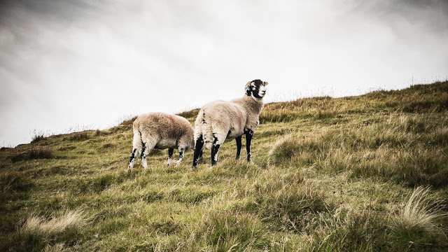
There were a few hikers around, a couple of fell runners (I don't know how they do it!) and a few hardy Cumbrian sheep grazing on the fells.
 |
| Sheltering from the wind |
 |
| Sheep on Blease Fell |
The downhill route zig-zags down Blease Fell and eventually arrives at the parking area at the end of Blease Road in Threlkeld.
Now for the refreshment ... We drove to the start of the walk to pick up the other car and then returned to Threlkeld for some well-earned refreshment in the Horse and Farrier, which is a delightful village inn serving local Jennings ales. Perfect!
Now for the refreshment ... We drove to the start of the walk to pick up the other car and then returned to Threlkeld for some well-earned refreshment in the Horse and Farrier, which is a delightful village inn serving local Jennings ales. Perfect!


Comments
Post a Comment